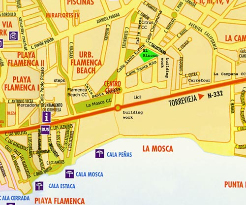
Playa Flamenca Detail Map

This map shows a smaller area of Playa Flamenca in more detail.
It has some of the new street names as well as the local commercial centres by name.
You can see the Flamenca Beach Commercial Centre as well as La Mosca CC, next door, in Calle Santa Alodia.
Also shown are Lidl, at the Alameda del Mar roundabout, and Carrefour along the N332 towards Punta Prima.
You can also see the walking route, via the steps to Calle Pablo Picaso, to the saturday market and to Mercadona.
At the Ayuntamiento - Town Hall - there is an underpass which allows you to cross the N332 to the beach at Playa Flamenca without taking your life in your hands.
Return from Playa Flamenca detail map to Playa Flamenca maps
Return to Visit Playa Flamenca home page
|
